
South Shore Blueway Trail draft plan presented
The draft plan for the proposed South Shore Blueway Trail was presented for public comment at a meeting November 14 at Village Hall in Freeport.
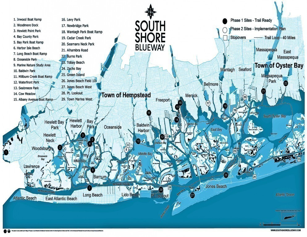
The Blueway Trail is a proposal for a 40-mile loop for non-motorized boats throughout the bays and inlets of Nassau County, connecting boat ramps and other places suitable for boats as well as stopover points along the circuit.
Kyle Rabin, the chair of the advisory committee, introduced Barbara La Rocco, president of Going Costal, a consulting firm (“Connecting People and Coastal Resources”) who prepared the plan with the assistance and input of the New York Department of State, volunteers and the advisory committee, a group of persons from governmental, community and environmental organizations joined by other stakeholders.
The road to the draft report
The plan began with money in the 2006 Nassau County Environmental Bond act dedicated to creating a water trail, combined with matching funds from Nassau County and the village of Freeport
Why have a water trail? The draft plan lists the many advantages that the trail would provide:
• Showcase one of Nassau’s greatest assets, its waterfront.
• Encourage recreation and healthy lifestyles.
• Increase environmental awareness and a connection with Long Island history.
• Teach boater awareness.
• Create a vehicle to encourage ecotourism and economic development. Ms La Rocco said that there are 1.8 million paddlers (kayak and stand-up paddlers) in New York state – a large potential market. Thus the trail could improve the local quality of life.
As presented in the draft plan, the loop would include the following sites, connected by a trail (although Ms. La Rocca noted that the accompanying map “should not be used for navigational purposes”):
• Woodmere
• Hewlett
• Bay Park
• Bay Park boat ramp
• Harbor Isle
• Long Beach Boat Ramp
• Oceanside Park
• Marine Nature Station Area (stopover)
• Baldwin Park
• Milburn Creek
• Waterfront Park, Freeport
• Seabreeze Park, Freeport (stopover)
• Cow Meadow Park, Freeport
• Albany Avenue, Freeport
• Levy Park
• Newbridge Road Park
• Wantagh Park
• Cedar Creek Park
• Seamans Neck Park
• Alhambra Road
• Burns Park
• Tobay Beach (stopover)
• Zachs Bay (stopover)
• Green Isle (stopover)
• Jones Beach Field 10
• Jones Beach West
• Point Lookout
• Town Marina, Point Lookout
The draft plan identifies 18 sites as ready for use, and eight sites as top priority for needed infrastructure – the plan includes drawings for the eight sites of pathways from parking to the dock lines with rubber matting and docks that will enable boats to get from the parking to the water:
Alhambra Park in Massappequa; Baldwin Park, Bay Park in East Rockaway, Cedar Creek Park, Newbridge Road Park, Oceanside Park, Seamans Neck Park and Waterfront Park.
Ms. La Rocca says the plan estimates a cost of $2 million, for which grant money will need to be raised, for the site improvement. Signage will also be needed, and the plan also foresees the need for other amenities such as concessions and boat storage facilities (there is no plan in place as yet for camping and lodging facilities).
In addition, a logo has already been designed as part of the “branding” of the trail – plan are included for brochures and maps – even T-shirts! And all sorts of possibilities exist for events to promote the trail – competitions, local history lessons and paddlers day events.
Where to go from here
Ms. La Rocco stated that it was hoped that the trail could be launched in the spring of 2014. But many things need to be done before that can happen:
• The draft plan must be finalized, and the advisory committee is seeking public comment. To view the draft plan in full, and to offer comment, you can go to the website at www.southshoreblueway.com
• construction analysis regarding the eight priority sites.
• The permitting process. Since at least six governmental bodies will need to be consulted in the process of obtaining permits needed to implement the plan – including New York State, Nassau County, the Towns of Hempstead and Oyster Bay and the Village of Freeport – A wide variety of rules and regulations will need to be adhered to.
• Phased development of the trail, with various parts of the plan being completed as funding becomes available.
Ms. La Rocco then answered questions regarding the details of the plan, which were mostly positive – with the exception of one attendee who wanted to know why the plan ignored the needs of sailboats. Ms. La Rocco noted that success of the plan was a gradual process, with attention needing to be given to the most basic parts of the plan – “the low lying fruit,” as she put it.
She then charged the attendees – many of whom are with organizations involved in the planning and eventual implementation of the plan – to provide support through volunteerism, letter writing and forming “Friends of the Blueway” organizations. “Funding will only come if the individual communities want access,” she said.


