
 44.0°,
Mostly Cloudy
44.0°,
Mostly Cloudy Valley Stream Historical Society: Old Central Avenue
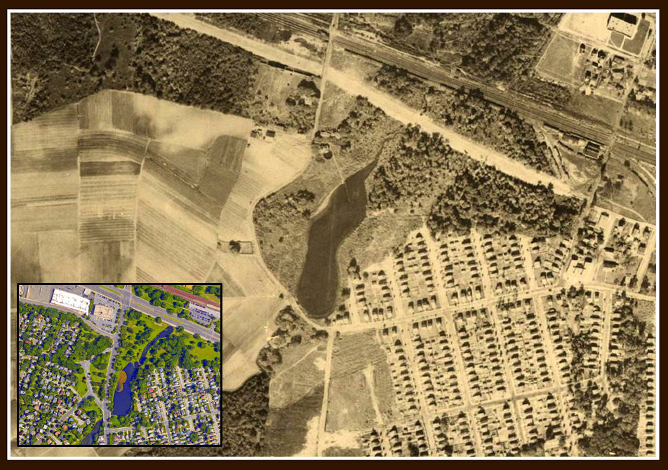
Merrick Road (originally Plank Road) is known by many to be one of the oldest thoroughfares in Valley Stream and beyond – it was constructed in 1853. But there is an even older, lesser known road that has been in continuous use since before that time. Let’s drive a bit south of Sunrise Highway and turn west off Mill Road onto Old Central Avenue, which serves as the entrance and egress to the Mill Brook (formerly Green Acres) community. A passive park buffers this elegant enclave – its western edge is curved, mimicking the letter “C,” and it is along this edge that the contour of Old Central Avenue was formed. This ancient road’s existence can be traced back to 1844, where it was first cited on J. Calvin Smith’s Map of Long Island with the Environs of New-York and the Southern Part of Connecticut – that’s 173 years ago! Frederick Reisert’s family, who owned and operated the truck farm that pre-dates Millbrook and the airfield before that, built their homesteads close to the road, making it convenient to load produce on to wagons for their weekly trip to Brooklyn’s Wallabout Market.
The pond that is located on the east side of Mill Road (Edward W. Cahill Memorial Park, formerly Watts Pond) is also directly linked to Old Central Avenue. The body of water was originally much larger – its east and west mid-sections bulged out in either direction, forcing the road to follow the natural shape of the pond. This 1926 sepia-toned aerial of the pond is identical in shape to not only the 1844 map but also to how the road looks today.
Location: west of Mill Road (between Flower and Woodland roads)


