
 50.0°,
Overcast
50.0°,
Overcast Bruce Blakeman declares an emergency in preparation for the storm
Strap down your outdoor decorations and prepare for high winds


Nassau County Executive Bruce Blakeman signed an emergency executive order Tuesday afternoon to prepare for the high wind and flooding event.
Although Blakeman noted that curfews and evacuations are unlikely, he signed the order just in case the forecast ends up being worse than expected. The order allocates more power to police commisioner Patrick Ryder for the possibiluty of facilitating a curfew. Whether or not curfews or evacuations happen, Blakeman urged residents at Tuesday's press briefing to stay indoors.
"Please don't go out if you have to," Blakeman said.
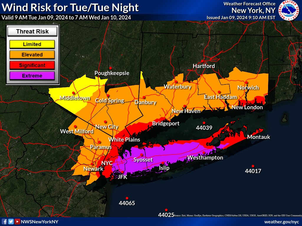
Blakeman pointed out that since his last briefing yesterday, the wind forecast got worse. The update forecast calls for gusts possibly reaching 70 mph. The rainfall totals, however, remains the same with 2 to 4 inches expected.
"I want to stress, if you have anything that can become airborne, bring it inside," Blakeman said. "Garbage cans, patio furniture,. If you can't bring it inside, tie them down."
With high winds comes the threat for power outages. Blakeman recommends residents to charge their electronic devices. He said if your power goes out, call PSE&G.
"We are expecting flooding on both the North Shore and South Shore," Blakeman said. "Although right now, the forecast is that it will be more profound on the South Shore and that could be a three-foot surge."
Blakeman said the brunt of the storm will be between 2 p.m. and 4 a.m.
"DPW will be out in full force," Blakeman said. "They already started cleaning drains from debris."
The National Weather Service issued a High Wind Warning, Flood Watch, and a Coastal Flood Warning. Winds of 30 to 40 mph expected with gusts up to 70 mph possible. Rainfall amounts of 2 to 4 inches forecasted with localized higher amounts possible.
PSEG Long Island alerted customers that the winds will be strong enough to potentially topple down trees, bring down branches and wires, and cause outages. More than 350 off-island utility personnel are being procured to work alongside PSEG Long Island's crews.
“PSEG Long Island is closely monitoring this latest weather front and we are once again prepared for potential impacts on the system,” Michael Sullivan, vice president of Electric Operations at PSEG Long Island, said in a press release. “We have performed system and logistic checks, and have a full complement of personnel who will mobilize for restoration in foul weather conditions. Our crews will work to safely restore any outages as quickly as conditions will allow.”
"You now have a saturated ground from all this rain that we received and now we're going to have even more rain," Don Clavin, Town of Hempstead Supervisor, said.
Clavin wants to remind residents of the rain storm over the summer that brought five inches of rain to the area. Although this storm will not have as much flooding, he is urging people to prepare for the worst case scenario.
"Stay off the roads overnight and just be ready for a difficult commute for not only your kids on Wednesday morning, but for youself," Clavin said.
According to Clavin, numerous crews fromn the highway sanitation will be going through areas that are known to be flood zones and cleaning storm drains. All of the Town's equipment at Point Lookout has been secured down. Clavin recommends residents to do the same with their outdoor decoration.
"If you haven't taken down your Christmas decorations, today's a great day to take it down," Clavin said. "Because on Wednesday, you might find it in front of your neighbor's house."
The High Wind Warning will be in place from Tuesday 6 p.m. to Wednesday 6 a.m., the Flood Watch is in place from Tuesday 6 p.m. to Wednesday 12 p.m., and the Coastal Flood Warning is in place from Tuesday 4 p.m. to Wednesday 1 p.m.


